The following open data has been released by the Open Data Challenge for Public Transportation 2025 – powered by Project LINKS-.
For details on the data, please refer to the respective linked sites. Additional data will be made available as it becomes ready.
Public Transportation Open Data Center
This platform for public transportation open data is operated by the Association for Open Data of Public Transportation. It provides data on railways, buses, ferries, airlines, and shared bicycles. Some data will be available exclusively for the challenge.

JR East's GTFS-formatted timetable data, GTFS-RT train location data, and operational information, along with a variety of other railway data, will be provided.

Timetable data in GTFS format for Toei buses and others, GTFS-RT bus location data, and a wide range of other bus data will be provided.

A variety of GTFS-formatted route information data will be provided.

Flight schedules and real-time arrival/departure information for airlines such as Japan Airlines and All Nippon Airways, along with other aviation-related data, will be provided.

docomo Bike Share and OpenStreet (Hello Cycling) will provide GBFS-formatted bike share station information.

GTFS-Flex data related to Demand Responsive Transportation will be provided.

GGTFS Data Repository
Municipalities and private bus operators that operate community buses release public transportation data, such as bus schedules, in GTFS format. This data, organized chronologically and registered in repositories, can be downloaded or accessed via API for use under an open license.
The operation is supported by the Japan Bus Information Association and managed by Association for Promotion of Infrastructure Geospatial Information Distribution.
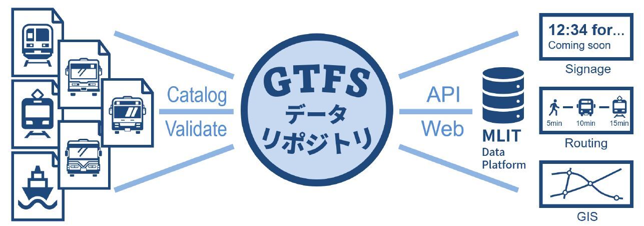

GTFS format data for railways operated by private operators, etc.

GTFS format data for community buses operated by municipalities and buses operated by private bus companies.

GTFS format data for ferries and maritime vessels.
Project LINKS
Various administrative information from within the Ministry of Land, Infrastructure, Transport and Tourism has been reconstructed as "data" for the purpose of utilizing it.
PLATEAU
This is a project promoted by the Ministry of Land, Infrastructure, Transport and Tourism in collaboration with various players to realize digital twins of cities across Japan. 3D city models are provided as open data so that anyone can freely extract city data.

Pedestrian Space Navigation Project (HokoNavi)
The Ministry of Land, Infrastructure, Transport and Tourism is promoting the open data of information on barriers such as steps in pedestrian spaces and information on barrier-free facilities.This project is working to realize an inclusive society in which everyone can move around autonomously and safely by promoting a variety of services that meet the various needs of people and robots using pedestrian spaces, such as route search and guidance that avoids steps and providing information on barrier-free facilities.

<Cooperative Open Data>
Please utilize the following open data sites as well.
- Ministry of Land, Infrastructure, Transport and Tourism: MLIT DATA PLATFORM
https://www.mlit-data.jp/ - Ministry of Land, Infrastructure, Transport and Tourism: Pedestrian mobile support service data site
https://www.mlit.go.jp/sogoseisaku/soukou/sogoseisaku_soukou_mn_000002.html - G-Spatial Information Center
https://www.geospatial.jp/ - Geospatial Information Authority of Japan: Basic Map
https://www.gsi.go.jp/kiban/ - Ministry of Internal Affairs and Communications: e-Stat, the Portal Site of Official Statistics of Japan
https://www.e-stat.go.jp/api/ - Tokyo Metropolitan Government: TOKYO OPEN DATA
https://portal.data.metro.tokyo.lg.jp/ - Tokyo Metropolitan Government: Construction Information
https://catalog.data.metro.tokyo.lg.jp/dataset/t000014d2000000028 - National Police Agency: Traffic Accident Statistics
https://www.npa.go.jp/publications/statistics/koutsuu/opendata/index_opendata.html - Japan Meteorological Agency: Weather data advanced use portal site
http://www.data.jma.go.jp/developer/index.html